![]() Map Handling
Map Handling
![]() Map Handling
Map Handling
|
<< Click to Display Table of Contents >>
|
  
|
A generic map control interface is used to control maps in various components. Since not all GUI items are useful for specific implementations some (GUI) elements may be disabled or made invisible. The following picture shows the generic layout of the map control.
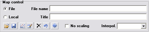
Typical map control GUI layout
•Map type
•File
A map is specified by a link where it can be found. In distributing models the maps should be given as well, and should be placed in exactly the same location as specified by the File name input string.
•Local
The map will be stored internally inside the project file. File stored
•File name
Path and filename to the loaded map. If the map resides next to the model/project, no path will be displayed. Manual file editing is disabled, selecting maps must be done using the browse button.
The color of the file name informs the user of the existence/state of the map file/object.
•Black font
A black font is used for a valid map location, i.e. a file with the specified name is found, for the File map option.
•Bright blue italic font
Embedding a map will immediately result in a bright blue font, this means that the map object has been embedded in the project node, and the path to the file still exists.
•Red italic font
For embedded maps the red font is introduced to indicate that the map path originally used to obtain the map data (on embedding map) is not valid anymore. An invalid map location can be the result of moving the project file to a different location/directory, or when the map files are moved.
•Title
Optional map title. If a map file has a title specified, the map title will be display after loading the map.
•Note that controlling maps is only possible using the buttons in the lower left corner.
From left to right these buttons stand for:
•Open map file (CTRL + O)
A map dialog will be opened to select a map file
•Save to file (CTRL + S)
Save the current loaded map to file
•Show map graph
Display the map's graphical representation
•Edit/view data (CTRL + E)
This will open the current loaded map in the default text editor
•Clear map data (CTRL + X)
This action will erase/clear the current loaded map
•Revert to model data as loaded when entering this config/case
Revert the map to the state the model config/case was entered (or last config/case save point)
•Help (F1)
Opens help
•No scaling
Resets map scale factors off-design to 1. This disables the automatic scaling to design point data for off-design analysis (no map scaling). This feature can be used when the component characteristics are known from testing or analysis. When enabled (of the shelf) component matching is possible.
•Interpol.
This drop-down box determines the type of interpolation. Linear interpolation is the default, but can be changed to Quadratic.
Note that some specific elements have been invisible when they are not applicable to the map (e.g. No scaling is sometimes not used).